The map is dead. Long live the reasoning engine: how AI is rewriting geospatial
The map is dead. Long live the reasoning engine: how AI is rewriting geospatial
For most of its history, a map was a picture: a static rendering of what is, where. The analyst did the thinking — drawing buffers, joining layers, interpreting the result. AI is quietly inverting that relationship. The map is becoming a reasoning engine — something you ask questions of, and that answers with conclusions rather than layer stacks. This article walks through the forces driving that shift, the numbers behind it, the systems already in production, and where the field is heading.
The market is already moving at scale
The commercial signal is unambiguous. Independent research firms, using different methodologies, converge on the same story: geospatial analytics is a large and fast-growing market, and the AI slice of it is growing fastest of all.
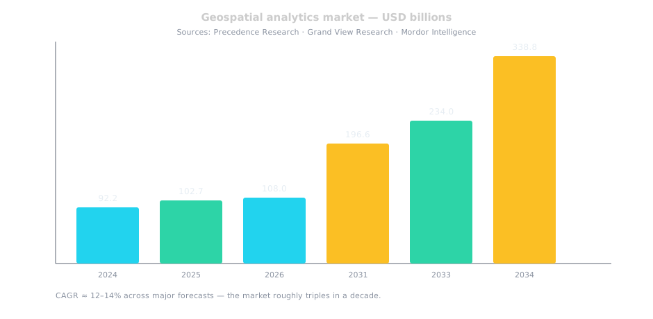
- Geospatial analytics overall: Precedence Research values the market at USD 92.19 billion in 2024, projected to reach USD 338.78 billion by 2034 (CAGR 13.90%). Grand View Research puts it at USD 102.7 billion in 2025 rising to USD 234.0 billion by 2033. Mordor Intelligence reports USD 108.03 billion in 2026 growing at 12.72% to USD 196.59 billion by 2031.
- AI in geospatial specifically: Precedence sizes the geospatial-analytics-AI segment at USD 38.33 billion in 2025, heading to USD 126.58 billion by 2035 (CAGR 12.69%). Technavio sees the AI-in-geospatial-technology market growing by USD 87.2 billion between 2025 and 2029 at a CAGR of 25.3% — the fastest-growing slice of the whole stack.
- The broader geospatial industry: Precedence estimates the full geospatial solutions market at USD 626.13 billion in 2024, projected to USD 2.16 trillion by 2034 (CAGR 13.16%). AI is the accelerant inside that growth.
The exact numbers differ by firm — that is normal for market research — but the direction is unanimous: a market that roughly triples in a decade, with the AI component compounding fastest. That is not hype; it is the market pricing in a structural change in how spatial work gets done.
The data problem AI is solving
The raw material of geospatial work has exploded. The CEDA Archive — the UK centre that hosts Copernicus Sentinel data — reports holding over 10 petabytes of satellite data, growing at more than 7 terabytes per day. NASA's EOSDIS describes its holdings the same way: petabytes of unrestricted Earth science data. The volume has long since outrun the human capacity to look at it.
This is the classic big-data trap, and it is exactly where AI earns its keep. A human analyst can inspect a handful of scenes; a model can sweep petabytes. The bottleneck in geospatial has never really been data — it has been the attention to turn that data into decisions. AI is the first tool that scales attention, not just storage.
The scale of the waste is stark. The EU's Copernicus Sentinels alone produce on the order of 20 terabytes of data daily, yet only about 2% of the data recorded by each satellite makes it back to Earth — the rest delayed, degraded, or discarded despite its potential value. When the constraint is not storage but the ability to process and interpret, the case for AI is not incremental; it is existential.
From rendering to reasoning
The deepest change is conceptual. Traditional GIS is descriptive — it renders what is. AI makes the stack reasoning: it can chain spatial operations (buffer → intersect → rank → decide) and return a conclusion. The map stops being the deliverable and becomes the evidence.
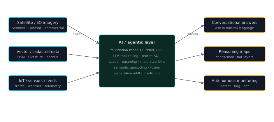
Concretely, that means:
- Conversational querying. "Show me flood risk within 500m of the Danube in Vienna" becomes a tool-calling chain — parse intent, resolve the place, buffer, spatial join, render — instead of a hand-written SQL pipeline. The analyst's job shifts from how do I query to what should I ask.
- Semantic spatial understanding. LLMs handle fuzzy geography — "near the old town," "the industrial quarter," colloquial boundaries — collapsing the gap between how humans think about space and how coordinates encode it. Geocoding becomes inference, not lookup.
- Data fusion as a solved problem. Geospatial data is famously messy — mismatched schemas, duplicate geometries, misaligned CRS. AI can reconcile Overture against GeoBoundaries against Natural Earth, harmonize attributes, and fill gaps. The data-wrangling tax that eats most of a project's time is the most automatable part.
- Generative geospatial. Synthetic geometries and plausible infill for missing data — useful for planning scenarios and training downstream models when real data is scarce.
Foundation models: the geospatial "GPT moment"
The most consequential trend is the arrival of geospatial foundation models — large models pre-trained on massive satellite imagery, then fine-tuned for specific tasks. The flagship is Prithvi-EO-1.0, a NASA–IBM transformer pre-trained on more than 1 terabyte of multispectral imagery from the Harmonized Landsat-Sentinel 2 (HLS) dataset. It is fine-tuned for multi-temporal cloud gap imputation, flood mapping, wildfire scar segmentation, and multi-temporal crop classification.
The successor, Prithvi-EO-2.0 (arXiv:2412.02732), is described as a "versatile multi-temporal foundation model for Earth observation applications." The numbers behind it are striking: it was trained on 4.2 million global time-series samples from the HLS archive at 30-metre resolution, incorporates temporal and location embeddings, and outperforms Prithvi-EO-1.0 by 8% across GEO-Bench tasks. NASA's open-source hls-foundation-os repository (NASA-IMPACT) provides the fine-tuning examples. The pattern is the same one that transformed NLP: a single pre-trained model, adapted cheaply to many tasks, instead of training each from scratch.
The implication is profound. Today, building a flood-mapping or crop-classification model means assembling a large labeled dataset and training from scratch — expensive and slow. With a foundation model, you fine-tune on a fraction of the data. The cost of building a new geospatial capability drops by orders of magnitude, which is what makes the market growth above plausible rather than aspirational.
AI already in production
This is not a future-tense story. Named systems are already doing the work:
- Flood forecasting at scale. Google's AI-powered flood forecasting, delivered through its Flood Hub, uses machine learning on satellite and gauge data to predict inundation — a system that has expanded to cover far more of the world than traditional physics-based models alone.
- Deforestation detection. Global Forest Watch's RADD (Radar for Detecting Deforestation) alerts use satellite-based radar to detect forest disturbance "rain or shine" — through clouds, smoke, and haze that optical sensors cannot see through.
- Agentic spatial analysis. Research such as "An LLM Agent for Automatic Geospatial Data Analysis" (arXiv:2410.18792) demonstrates LLMs driving multi-step geospatial data processing — the agentic pattern applied to spatial work.
These are not demos. They are operational systems used by governments, NGOs, and insurers. The common thread: each one replaces a slow, manual, expert-only workflow with something a model can do continuously and at planetary scale.
The outlook: trends to watch
Looking forward, five trends stand out:
- Foundation models become the default substrate. Expect more Prithvi-class models — including weather and climate variants like
Prithvi WxC(arXiv:2409.13598) — and a shift from task-specific training to fine-tuning. - Agentic GIS. LLM agents that plan, execute, and verify multi-step spatial analyses will become the standard interface, not a novelty. Text-to-SQL and text-to-map are the first wave; autonomous spatial reasoning is next.
- Autonomous monitoring. Agents that watch live feeds — traffic, weather, IoT, satellite — with spatial awareness and act on what they see: detect a new footprint, flag a zoning anomaly, trigger an alert. Monitoring becomes continuous, not scheduled.
- Multimodal spatial intelligence. Vision models reading imagery fused with vector data and text. The boundary between "imagery" and "data" dissolves — a model looks at a scene and answers spatial questions about it.
- The value chain inverts. The bottleneck moves from tooling to judgment. Data pipelines become self-maintaining; the scarce skill becomes asking good spatial questions and verifying answers — not operating software. GIS stops being a guild.
AI does not replace geospatial analysis — it removes the friction between a human intent and a spatial answer. The map stops being the deliverable and becomes the evidence.
The bottom line
The geospatial landscape is being reshaped along one axis: from descriptive to reasoning. The market is tripling in a decade, the AI slice is compounding fastest, petabytes of imagery are finally being put to work, foundation models are collapsing the cost of new capabilities, and agentic systems are turning maps into conversational, autonomous decision engines. The analyst of the near future will not spend their day operating software — they will spend it asking better questions and trusting the stack to reason about space.
Sources
- Precedence Research — Geospatial Analytics Market (USD 92.19B 2024 → USD 338.78B 2034, CAGR 13.90%) — https://www.precedenceresearch.com/geospatial-analytics-market
- Precedence Research — Geospatial Analytics AI Market (USD 38.33B 2025 → USD 126.58B 2035, CAGR 12.69%) — https://www.precedenceresearch.com/geospatial-analytics-artificial-intelligence-market
- Precedence Research — Geospatial Solutions Market (USD 626.13B 2024 → USD 2,155.72B 2034, CAGR 13.16%) — https://www.precedenceresearch.com/geospatial-solutions-market
- Grand View Research — Geospatial Analytics Market (USD 102.7B 2025 → USD 234.0B 2033) — https://www.grandviewresearch.com/industry-analysis/geospatial-analytics-market-report
- Mordor Intelligence — Geospatial Analytics Market (USD 108.03B 2026 → USD 196.59B 2031, CAGR 12.72%) — https://www.mordorintelligence.com/industry-reports/geospatial-analytics-market
- Technavio — AI in Geospatial Technology Market (USD 87.2B growth 2025–2029, CAGR 25.3%) — https://www.technavio.com/report/ai-in-geospatial-technology-market
- CEDA Archive — Sentinel data volume (10+ PB, 7+ TB/day) — https://www.ceda.ac.uk/news/updates/2021/2021-11-04-sentinel-data-variety-and-volume/
- Satellite Evolution Group — Copernicus data volume & 2% downlink (20 TB/day, ~2% of recorded data reaches Earth) — https://www.satelliteevolutiongroup.com/
- NASA EOSDIS (petabytes of unrestricted Earth science data) — https://www.earthdata.nasa.gov/eosdis
- Prithvi-EO-1.0 (NASA–IBM) — https://huggingface.co/ibm-nasa-geospatial/Prithvi-EO-1.0-100M
- Prithvi-EO-2.0 paper — https://arxiv.org/abs/2412.02732
- NASA-IMPACT hls-foundation-os — https://github.com/NASA-IMPACT/hls-foundation-os
- Prithvi WxC (weather & climate) — https://arxiv.org/abs/2409.13598
- Google AI flood forecasting — https://blog.google/outreach-initiatives/sustainability/ai-powered-flood-forecasting-scale/
- Global Forest Watch RADD alerts — https://www.globalforestwatch.org/blog/data/radd-radar-alerts/
- An LLM Agent for Automatic Geospatial Data Analysis — https://arxiv.org/abs/2410.18792